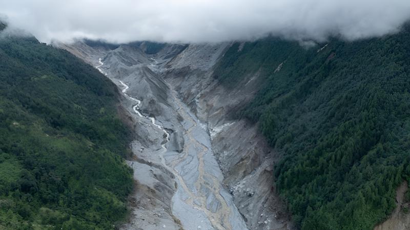
Sep 13, Kathmandu - A massive landslide, not a glacier burst, has been confirmed as the primary cause of the destructive floods along the Bhotekoshi and Trishuli river corridors on Bhadra 10. The incident was triggered by a colossal landslide from the upper reaches of the Langtang-Lirung Himalayan range, according to a recent study.
The Department of Hydrology and Meteorology, along with disaster research organizations, released a detailed study revealing that approximately 14.2 million cubic meters of snow, large rocks, soil, and debris rapidly descended into the rivers, creating a devastating flood. This natural disaster resulted from a sudden collapse of a massive ice and rock mass from the northwest slope of Langtang Lirung, located around 5,200 meters above sea level.
The study states that the landslide, which measured about 600 meters wide and 70 meters thick, fell approximately 1,400 meters into the valley of the Lhende River at dawn around 8:37 a.m. The impact was comparable to a magnitude 5.2 earthquake, causing intense seismic waves. The friction and heat generated by the fall rapidly melted the snow, transforming it into a massive mudslide that swept away old debris, soil, and trees, further amplifying the destructive power.
The resulting landslide crossed Nepal’s northern border into China’s Tibet, passing through Kerung and re-entering Nepal via Rasuwagadhi. It then flowed into the Bhotekoshi and Trishuli rivers, causing widespread destruction.
Warning System Shortcomings and Human Toll
The report highlights that the significant human casualties were largely due to the delayed warning system. The time lag between the issuance of warnings and the actual flood arrival was critical; many automatic water measurement devices in Rasuwagadhi, Timure, and Syafrubesi were destroyed before they could alert residents.
Within just 12.8 minutes of the landslide, floodwaters reached populated areas. However, official alerts via satellite and central systems took nearly 39 minutes to reach the public, leaving residents with no time to evacuate safely. This “negative lead time” in warning systems meant that communities in upper Rasuwa and Nuwakot had no chance to escape.
Unprecedented Damage to Infrastructure and Economy
The floods inflicted severe damage on Nepal’s north-south trade routes and energy infrastructure. Over 14 hydroelectric projects with a combined capacity of approximately 748 MW—many under construction or operational—were partially or destroyed, causing a major energy crisis.
Key infrastructural losses include the historic Rasuwagadhi-Miteri border bridge connecting Nepal and China, along with roads, bridges, customs offices, and the Pulchowk Pass highway—all washed away. The initial technical assessment estimates damages exceeding NPR 400 billion, affecting roads, private property, and the energy sector.
Reconstruction and Long-term Recommendations
The report emphasizes that this disaster exemplifies the increasing risks posed by climate change in Himalayan regions. To mitigate future threats, it recommends implementing satellite-based and seismographic early warning systems capable of detecting landslides and snowfall in high-altitude areas promptly.
Furthermore, a national plan suggests allocating over NPR 130 billion for reconstruction, river control, resettlement of displaced populations, and reopening vital highways. It also calls for relocating vulnerable markets near riverbanks—such as Timure, Syafrubesi, and Betrawati—to safer, higher ground through integrated development strategies.















 Indian Rupee
 U.S. Dollar
 European Euro
 UK Pound Sterling
 Swiss Franc
 Australian Dollar
 Canadian Dollar
 Singapore Dollar
 Japanese Yen
 Chinese Yuan
 Saudi Arabian Riyal
 Qatari Riyal
 Thai Baht
 UAE Dirham
 Malaysian Ringgit
 South Korean Won
 Swedish Kroner
 Danish Kroner
 Hong Kong Dollar
 Kuwaity Dinar
 Bahrain Dinar